PORT CAMPBELL, THE GREAT OCEAN ROAD, VICTORIA - 22nd December 2009
Continued from Days
1 and
2...
DAY 3 With a fair whack of distance to travel today, I was up and out of my hostel in Lorne by about 9.15 and off south-eastward down the GOR. The first port of call wasn't far, however, as I'd decided I was not going to have peace until I saw a koala in the wild.
Kennett River, between Lorne and Apollo Bay, has a "Koala Forest Trail" walk that seemed to offer as good an opportunity as any, so I stopped off there and began the hour-long ascent up from the seaside into the shaded abyss of the forest of gum trees. Trying to spot little furry animals in massive trees is not the easiest of tasks, and I had little success on my own. Thankfully, a few other groups of people were driving the path (lazy gits) and had an incredibly sharp eye for the creatures, so I just went to wherever I saw them stopping. Sure enough, between about 3 cars of people we came across about 7 or 8 koalas sitting, dozing in the gums, but the last one we saw was wide awake on a branch above the trail path, munching away on the eucalyptus leaves and generally posing for the cameras.
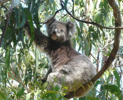
As a bit of an educational aside, koala bears are not actually bears in any shape or form - like kangaroos and lots of other indigenous Australian creatures, they are marsupials - their closest relatives are wombats. As a general rule, marsupials are incredibly energy-efficient creatures, needing just 20% of the food intake of an equivalent-sized placental mammal to survive (spanning everything in size from rats to whales). The need for this energy efficiency is obvious in Australia's dry, largely barren and desolate landscape. The koala, however, has taken this efficiency to an extreme, with the latest biological insight concluding that the reason it, unlike any other living creature, has a brain smaller than its skull ("a walnut of a brain rattling around in a fluid-filled cranium"), is that that its brain has been sacrificed in the name of energy efficiency. Brains need a lot of power - our human brain uses 20% of our energy, despite being only 2% of our mass - and koalas don't have energy to spare thanks to a diet solely consisting of gum tree (eucalyptus) leaves - a leaf so toxic that 20% of their energy is spent just detoxifying it (leave alone digesting it). As the LPG correctly notes, "there is no doubt that the koala is not the Einstein of the animal world". However, living up in the treetops with no predators of note, they can happily doze their time away, spending 75% of their day asleep.
Happy as Larry with a camera full of awesome wild koala snaps, I was soon back on the GOR, passing through Apollo Bay again before the road heads inland around the coastal peninsula of the Otway National Park. Without any CDs or an iTrip for the iPod, I was forced to use that ancient medium of radio to entertain my ears - and was pleasantly surprised by what was on offer. Having enjoyed the rock'n'roll of
Vega 91.5 through Melbourne and the cheesy classics of
Bay FM round the Bellarine Peninsula, this particular stretch of journey had
95.9 Mixx FM as its soundtrack - principally because the towering Mountain Ash trees lining the road prevented any reception from anywhere further afield than Apollo Bay!

About 30km further inland from the GOR is the
Otway Fly -
a massive system of raised walkways running through one of the few remaining preserves of Victoria's natural rainforest. The fly system is one of only 3 in the world - all of which are in Australia - and rises 25 metres (85 feet) off the forest floor allowing you to walk through the different layers of canopy for its 600 metre length. In the middle, rising up alongside the towering Mountain Ash eucalypts, is the 45 metre (150 feet) high viewing tower which takes you up to the top of the canopy by a spiral staircase (see right), and gently sways in the breeze as a result of its central pillar support structure. The trees are magnificent - it is hard to comprehend just how big they are when you look at them because it is equally hard to comprehend just how high you are off the ground, and for the same reason photographs, like the one below, simply cannot do justice to what you're actually experiencing. For all the uniqueness of the Fly, however, I wasn't massively impressed by the $22 entry fee - it was cool, but not
that cool...

Out the other side of Otway National Park, the GOR once again meets up with the coastline, although now west of Cape Otway we were running along the factually accurate, if a shade melodramatic, "Shipwreck Coast" (in contrast to the touristy clichéd "Surf Coast" to the north-east of the Cape). The stretch of the coast contains the most photographed section of the GOR - either side of Port Campbell lie a series of spectacular rock formations including "
the Twelve Apostles", "
The Arch" and "
London Bridge" - all formed as a result of the gradual erosion of the limestone sedimentary rock of the cliff face. The area is like coastal geography in action - I'm fairly sure it'd be like Christmas-coming-early for Miss Kateley or Larkin or the rest of the "geoggers" crowd - there are stacks and gorges and islets and all the other buzzwords, and over 10 years you can see the photographic change. The catalyst is the relentless force of the sea water coming up against limestone cliffs, which are eroded away over time leaving a protruding cliff with harder rock as the headland. The weaker rock around the edges will continue to be eroded behind the headland, forming caves on either side that are eventually eroded through to form an arch. Eventually, as the width of the arch is forced to increase, it will collapse, leaving behind an isolated "stack", which itself will gradually disappear or collapse. The Twelve Apostles, below, are such stacks, and now number just 6 (or 7, depending how you count them), after a 50m stack collapsed in 2005. It is unlikely that 12 were ever visible from any one point, put the name was catchier than the "Sow and Piglets" name that it succeeded...

Still within the broader Port Campbell National Park, but the other side of the Port Campbell township, "The Arch" is a natural archway carved out of the rock in the manner described above and, although resplendent now, will eventually collapse in on itself and leave behind an isolated stack like the Apostles further up the coast.

This, in fact, is exactly what happened in 1990 over at the equally impressive
London Bridge - the photo below shows the gaping hole between the main headland and what is now an isolated arch, after the adjoining part of the "Bridge" collapsed. Apparently a couple of tourists ended up trapped on the newly isolated stack when the middle caved in, and needed to be rescued by helicopter...
according to Wikipedia.

As you continue to head westward away from Port Campbell, you eventually reach the tiny village of
Peterborough (population: 178), which has the dubious claim of being the centrepoint for shipwrecks on the Shipwreck Coast. With rocky outcrops all over the place and infamously choppy seas on the Bass Strait, not to mention a total lack of lighthouses back in the mid-nineteenth century, a good half a dozen vessels came to ground within a mile or so of Peterborough, including the
Falls of Halladale, which sat aground off the Peterborough coast for months as a tourist attraction before eventually succombing to the might of the waves, and the
SS Schomberg, which was designed with the sole purpose of eclipsing the record for the fastest journey from Liverpool to Melbourne, but came to a sticky end just a day's sail from its destination. A look across the water from the village tells a story - in among the expanse of water are a collection of random outcrops of rock - barely a few feet higher than the water level and almost certainly invisible in bad light.
En route through Port Campbell I'd stopped off for a bite, a swim in the sea, and to book some accommodation for the night, and so it was back to Port Campbell in the evening after seeing everything there was to see further up the road. My hostel sits on the best piece of real estate in the town - the front verandah sits right on the beach which is enclosed by large headlands on either side of it. While swimming at lunchtime, I'd noticed a path running up the side of the eastern headland from the edge of the beach, so I decided to build up an appetite for dinner by taking a stroll on what turned out to be called the "Port Campbell Experience Trail". Up on the trail, I got talking the a young family who were out for a post-dinner stroll - a couple with 4-year-old and 2-year-old boys. Turned out the Dad was the local police officer for the town, and the couple had moved to Port Campbell from Melbourne a couple of years back and loved it. As happens, we ended up having a long, winding chat about everything from my travel plans to the state of the world economy and the weakness of Pound Sterling, but they also pointed out some spectacular views looking eastward back up the GOR - from the end of the Port Campbell headland you can see right back up to the 12 Apostles - the stacks visible on the right hand side of the photo below. All the while, the sun was gradually working its way down to sea level, and the evening afterglow produced a stunning orange hue in the limestone cliffs, beautifully contrasting with the aquamarine blue of the ocean and the wild green of the shrubbery around us. It was one of those moments where you just wanted to keep looking, keep absorbing the image, capture the moment in time and never leave it. Instead, I have to make do with the photo!

The clouds in the sky were absolutely perfect, producing the most idyllic backdrop as we got back to Port Campbell's inlet beach, with the sun setting over another amazing day down the Great Ocean Road:


 The pukará itself (right) was similar in many ways to the one Tom and I tore up back in Chilcara, although getting to the top involved a much bigger climb and lacked the hundreds of here's-where-someone-had-a-dump-400-years-ago memorial cacti. However, what made this place poles apart was the view. The mesmerising mixture of colours, their shades and their depth, added what can only be described as a surreal hue to a scene that would blow off your socks in black and white alone. As illustrated:


 Posts
Posts


